

A winter storm is set to sweep across Western Oklahoma, bringing a mix of snow, sleet, and freezing rain over the next 24 hours. The most significant impacts are expected Tuesday night into Wednesday morning, with meteorologists warning of treacherous road conditions, possible power outages, and school closures.
Weather Timeline & Impacts
Monday Night: Rain will develop after midnight as temperatures dip to 31°F. Winds will shift from the south-southeast to northeast at 7-11 mph.
Tuesday: A mix of rain and sleet is possible in the morning, transitioning to rain and snow in the afternoon. Highs will reach 36°F with gusty northeast winds up to 26 mph.
Tuesday Night: The most hazardous conditions arrive overnight as freezing rain, snow, and sleet move in. Lows will drop to 23°F, with winds gusting up to 21 mph. A 100% chance of precipitation means roads and bridges will become dangerously slick.
Wednesday: Freezing rain and sleet will turn to snow before tapering off by noon. Highs will struggle to reach 29°F, with strong north winds gusting up to 28 mph.
The Oklahoma Panhandle has an 80% chance of snow, while southern and southeastern Oklahoma are expected to receive mostly rain.
What to Expect
High Risk: Icy roads and dangerous travel conditions, especially overnight Tuesday into Wednesday.
Medium Risk: Power outages and school closures.
Low Risk: Pipe bursts, as below-freezing temperatures won’t last long.
Winter Weather Advisory in Effect
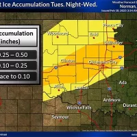
A Winter Weather Advisory has been issued from 6 PM Tuesday to Noon Wednesday for multiple counties, including Roger Mills, Custer, Beckham, and Washita. Expected impacts include:
Snow and sleet accumulations up to two inches
Ice accumulations up to two-tenths of an inch
Hazardous travel conditions on roads, bridges, and overpasses
Officials urge residents to slow down, use caution when driving, and stay updated on closures and road conditions by calling 511.