

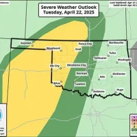
Western Oklahoma – Western Oklahoma residents—especially those in Beckham, Custer, Roger Mills, and Washita counties—should stay weather-aware through the rest of this week. The Storm Prediction Center continues to highlight the region with ongoing risks for severe storms, beginning Tuesday, April 22 and potentially continuing through Friday, April 25.
Key Threats (Tuesday–Friday):
??? Damaging Winds: 15–29% chance across the region, with the potential for isolated wind gusts exceeding 74 mph—especially Tuesday and Thursday.
?? Large Hail: 15–29% chance, with some areas seeing hailstones over 2 inches in diameter. Wednesday and Thursday carry the highest hail potential.
?? Thunderstorms: Storms could develop each afternoon and evening, with potential for rapid intensification. Some may become supercells, particularly on Thursday.
Areas Most at Risk:
Elk City, Clinton, Sayre, Cheyenne, and Cordell remain in the zone of concern. Locations west of I-35 are especially vulnerable to sudden storm development.
?? Stay Alert: Tune in to 96.5FM KECO and KOOL 94.3FM for continuous severe weather coverage and live updates. We’re on-air and online to keep you informed.